insolation
A collection of python functions to compute insolation over tilted surfaces or complex terrain.
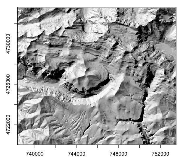
Intensity of illumination on a DEM of the Pyrenees with an hypothetical sun at 315° azimuth and 35° elevation.
Python implementation
At github: https://github.com/jgcmeteo/insolation
At pypi: https://pypi.org/project/insolation/
Full documentation at: https://www.meteoexploration.com/insol/python/index.html
Installation
pip install insolation
If you plan to use the cast shadows algorithm, doshade function, do also:
pip install numba
R implementation
Code and documentation at: https://meteoexploration.com/R/insol/
Archived versions at CRAN https://cran.r-project.org/src/contrib/Archive/insol/
R insol is no longer maintained at CRAN, some Mozilla browsers under certain linux versions complained about the SSL certificate of a page hosting a GEOTiff for a "not run" example and CRAN was way too impatient and demanding to continue a friendly (and free) cooperation.
Installation R
curl  -o insol_1.2.2.tar.gz https://meteoexploration.com/R/insol/src/insol_1.2.2.tar.gz
R CMD install insol_1.2.2.tar.gz
Uses of insol (insolation)
The insolation code is based on the work listed in the references. The algorithms to evaluate the sun position relative to complex terrain or tilted surfaces are based on Corripio (2003). The package has been used in a wide range of studies, such as solar energy, glaciology, snow avalanches, hydrology, botany, forest management, agriculture, animal behaviour, apiculture or climatology. Some recent papers using insol /insolation are listed below, a more comprehensive list can be obtained from google scholar and other scientific publications databases.
Bright, R.M., Bogren, W., Bernier, P. and Astrup, R., 2016. Carbon‐equivalent metrics for albedo changes in land management contexts: relevance of the time dimension. Ecological Applications, 26(6), pp.1868-1880.
Casirati, S., Conklin, M.H. and Safeeq, M., 2023. Influence of snowpack on forest water stress in the Sierra Nevada. Frontiers in Forests and Global Change, 6, p.1181819.
Corripio, J.G.; López-Moreno, J.I. Analysis and Predictability of the Hydrological Response of Mountain Catchments to Heavy Rain on Snow Events: A Case Study in the Spanish Pyrenees. Hydrology 2017, 4, 20. https://doi.org/10.3390/hydrology4020020
Cowling, R.M. and Potts, A.J., 2015. Climatic, edaphic and fire regime determinants of biome boundaries in the eastern Cape Floristic Region. South African Journal of Botany, 101, pp.73-81.
Doherty, K.D., Kuhlman, M.P., Durham, R.A., Ramsey, P.W. and Mummey, D.L., 2021. Fine-grained topographic diversity data improve site prioritization outcomes for bees. Ecological Indicators, 132, p.108315.
Durham, R.A., Doherty, K.D., Antoninka, A.J., Ramsey, P.W. and Bowker, M.A., 2018. Insolation and disturbance history drive biocrust biodiversity in Western Montana rangelands. Plant and Soil, 430, pp.151-169.
Eitel, J.U., Maguire, A.J., Boelman, N., Vierling, L.A., Griffin, K.L., Jensen, J., Magney, T.S., Mahoney, P.J., Meddens, A.J., Silva, C. and Sonnentag, O., 2019. Proximal remote sensing of tree physiology at northern treeline: Do late-season changes in the photochemical reflectance index (PRI) respond to climate or photoperiod?. Remote sensing of environment, 221, pp.340-350.
Exley, G., Armstrong, A., Page, T. and Jones, I.D., 2021. Floating photovoltaics could mitigate climate change impacts on water body temperature and stratification. Solar Energy, 219, pp.24-33.
George, A.D., Thompson III, F.R. and Faaborg, J., 2015. Using LiDAR and remote microclimate loggers to downscale near-surface air temperatures for site-level studies. Remote sensing letters, 6(12), pp.924-932.
Grabowski, P.P., Evans, J., Daum, C., Deshpande, S., Barry, K.W., Kennedy, M., Ramstein, G., Kaeppler, S.M., Buell, C.R., Jiang, Y. and Casler, M.D., 2017. Genome‐wide associations with flowering time in switchgrass using exome‐capture sequencing data. New Phytologist, 213(1), pp.154-169.
Herce, M.F., Martorell, C., Alonso‐Fernandez, C., Boullosa, L.F.V.V. and Meave, J.A., 2014. Stem tilting in the inter‐tropical cactus E chinocactus platyacanthus: an adaptive solution to the trade‐off between radiation acquisition and temperature control. Plant Biology, 16(3), pp.571-577.
Jackson, F. L., Hannah, D. M., Ouellet, V., & Malcolm, I. A. (2021). A deterministic river temperature model to prioritize management of riparian woodlands to reduce summer maximum river temperatures. Hydrological Processes, 35(8), e14314. https://doi.org/10.1002/hyp.14314
Jiménez‐Robles, O. and De la Riva, I., 2019. Lizards in the mist: Thermal niches constrained by habitat and microclimates in the Andes of southern Bolivia. Journal of Biogeography, 46(8), pp.1676-1686.
Jueterbock, A., Smolina, I., Coyer, J.A. and Hoarau, G., 2016. The fate of the Arctic seaweed Fucus distichus under climate change: an ecological niche modeling approach. Ecology and Evolution, 6(6), pp.1712-1724.
Kattenborn, T., Hernández, J., Lopatin, J., Kattenborn, G. and Fassnacht, F.E., 2018. Pilot study on the retrieval of DBH and diameter distribution of deciduous forest stands using cast shadows in uav-based orthomosaics. ISPRS annals of the photogrammetry, remote sensing and spatial information sciences, 4, pp.93-99.
Leidman, S., Rennermalm, Å.K., Lathrop, R.G. and Cooper, M., 2021. Terrain-based shadow correction method for assessing supraglacial features on the Greenland ice sheet. Frontiers in Remote Sensing, p.20.
Maguire, A.J., Eitel, J., Griffin, K., Schmiege, S.C., Bruner, S.G., Boelman, N. and Weygint, W., 1785. ABoVE: Needle-Level Chlorophyll Fluorescence, Alaska and Idaho, USA, 2017 and 2019. ORNL DAAC, Oak Ridge, Tennessee, USA.
Maguire, A.J., Eitel, J.U., Griffin, K.L., Magney, T.S., Long, R.A., Vierling, L.A., Schmiege, S.C., Jennewein, J.S., Weygint, W.A., Boelman, N.T. and Bruner, S.G., 2020. On the functional relationship between fluorescence and photochemical yields in complex evergreen needleleaf canopies. Geophysical Research Letters, 47(9), p.e2020GL087858.
Morhart, C., 2018. Modelling shadow in agroforestry systems based on 3D data. In European Agroforestry Conference-Agroforestry as Sustainable Land Use, 4th. EURAF.
Morozumi, T., Kato, T., Kobayashi, H., Sakai, Y., Tsujimoto, K., Nakashima, N., Buareal, K., Lan, W. and Ninomiya, H., 2023. Row orientation influences the diurnal cycle of solar-induced chlorophyll fluorescence emission from wheat canopy, as demonstrated by radiative transfer modeling. Agricultural and Forest Meteorology, 339, p.109576.
Murgatroyd, M., Photopoulou, T., Underhill, L.G., Bouten, W. and Amar, A., 2018. Where eagles soar: Fine‐resolution tracking reveals the spatiotemporal use of differential soaring modes in a large raptor. Ecology and Evolution, 8(13), pp.6788-6799.
Olson, M., Rupper, S. and Shean, D.E., 2019. Terrain induced biases in clear-sky shortwave radiation due to digital elevation model resolution for glaciers in complex terrain. Frontiers in Earth Science, 7, p.216.
Redhead, J.W., Burkmar, R., Brown, M. and Pywell, R.F., 2022. E-Planner: A web-based tool for planning environmental enhancement on British agricultural land. Environmental Modelling & Software, 155, p.105437.
Rouse, S., Behnoud, P., Hobeali, K., Moghadas, P., Salahshour, Z., Eslahi, H., Ommatmohammadi, M., Khani, A., Shabani, A., Macdonald, D.W. and Farhadinia, M.S., 2021. Intraspecific interactions in a high‐density leopard population. Ecology and Evolution, 11(23), pp.16572-16584.
Rupp, D.E., Shafer, S.L., Daly, C., Jones, J.A. and Frey, S.J., 2020. Temperature gradients and inversions in a forested Cascade Range basin: Synoptic‐to local‐scale controls. Journal of Geophysical Research: Atmospheres, 125(23), p.e2020JD032686.
Silverio, D.V., Brando, P.M., Macedo, M.N., Beck, P.S.A., Bustamante, M.M.C. and Coe, M.T., 2019. Net Radiation and Albedo from MODIS for Xingu River Basin, Brazil, 2000-2012. ORNL DAAC, Oak Ridge, Tennessee, USA.
Tarricone, J., 2023. Advancing the Monitoring Capabilities of Mountain Snowpack Fluctuations at Various Spatial and Temporal Scales (Doctoral dissertation, University of Nevada, Reno).
Vazquez, C., Rowcliffe, J.M., Spoelstra, K. and Jansen, P.A., 2019. Comparing diel activity patterns of wildlife across latitudes and seasons: Time transformations using day length. Methods in Ecology and Evolution, 10(12), pp.2057-2066.
Verocai, M., Castro, M., Manasliski, S. and Mazzilli, S.R., 2022. Frost risk in canola and carinata as a function of sowing date in the agricultural central region of South America. Agronomy Journal, 114(5), pp.2920-2935.
Wallach, D., Palosuo, T., Thorburn, P., Hochman, Z., Andrianasolo, F., Asseng, S., Basso, B., Buis, S., Crout, N., Dumont, B. and Ferrise, R., 2021. Multi-model evaluation of phenology prediction for wheat in Australia. Agricultural and Forest Meteorology, 298, p.108289.
Weygint, W.A., Eitel, J.U., Maguire, A.J., Vierling, L.A., Johnson, D.M., Campbell, C.S. and Griffin, K.L., 2023. Leaf temperatures and environmental conditions predict daily stem radial variations in a temperate coniferous forest. Ecosphere, 14(3), p.e4465.
References
The algorithms used in insol/insolation are based on the following publications:
Bird, R. E. and Hulstrom, R. L. (1981a) Review, evaluation and improvements of direct irradiance models, Trans. ASME J. Solar Energy Eng. 103, 182-192.
Bird, R. E. and Hulstrom, R. L. (1981b) A simplified clear sky model for direct and diffuse insolation on horizontal surfaces, Technical Report SERI/TR-642-761, Solar Research Institute, Golden, Colorado.
Bourges, B.: 1985, Improvement in solar declination computation, Solar Energy 35(4), 367-369.
Brutsaert, W.: 1982, Evaporation into the atmosfphere: theory, history, and applications, Reidel, Dordrecht.
Corripio, J. G. (2003). Vectorial algebra algorithms for calculating terrain parameters from DEMs and solar radiation modelling in mountainous terrain. International Journal of Geographical Information Science, 17(1), 1–23. https://doi.org/10.1080/713811744
Danby, J. M. Eqn. 6.16.4 in Fundamentals of Celestial Mechanics, 2nd ed. Richmond, VA: Willmann-Bell, p. 207, 1988.
Iqbal, M. (1983) An Introduction to Solar Radiation, Academic Press, Toronto.
Jacobson, M. Z.: 1999, Fundamentals of atmosfpheric Modeling, Cambridge University Press, Cambridge.
Lowe, P. R.: 1977, An approximating polynomial for the computation of saturation vapor pressure, Journal of Applied Meteorology 16, 100-103.
Meeus, J. 1999. Astronomical Algorithms. Willmann-Bell, Richmond, Virginia, USA.
Reda, I. and Andreas, A. 2003. Solar Position Algorithm for Solar Radiation Applications. 55 pp.; NREL Report No. TP-560-34302, Revised January 2008. https://www.nrel.gov/docs/fy08osti/34302.pdf
US Standard Atmosfphere U.S. NOAA: 1976, U.S. standard atmosfphere, 1976, NOAA-S/T# 76-1562, U.S. National Oceanic and atmosfpheric Administration, National Aeronautics and Space Administration, United States Air Force, Washington. 227 pp.

Terrain slope in a mountain valley in the Cantabrian Mountains, Spain. The green mask shows areas under 12° of inclination, which match the areas occupied by grazing pastures.