Weather for mining operations

Weather for mining operations in extreme environments

Weather for extreme environments

We provide high resolution meteorological data and maps, to facilitate the planning and logistics of operations on complicated terrain.

Based on our previous experience of meteorological prediction in extreme areas, such as the Antarctic or rescue operations in the Himalayas, we created a tool specific to high altitude mining operations in difficult terrain.

Using the Weather Research and Forecast Model-WRF to up to one km of resolution and higher resolution topographic data, we can provide a reliable forecast to aid the teams of meteorologists in charge of evaluating the environmental risks.

A reliable forecast helps planning ahead, reducing losses, keeping any interruptions due to weather conditions to a minimum and increasing the overall security at the operation site. It also helps organising the work schedule more efficiently, maximising the use of available resources.

An accurate weather prediction helps minimise the environmental impact of the operations. For example, coordinating open mine explosions with favourable wind conditions, makes it possible to reduce the risk of deposition of fine particulate matter on glaciers and other sensitive areas. It is also possible to save water by watering dust roads at the most suitable times.

Trustworthy forecasts mean greater security for the work force. Being able to anticipate the condition of the roads and tracks, if snow ploughs are necessary, what routes may be blocked, etc., helps to ensure safer working conditions.

A precise forecast of wind speed and direction and snow fall is essential for an accurate assessment of the avalanche risk.

A detailed air and surface temperature prediction along a route can help anticipate the need for snow chains, salting and the general state of the roads.

You can try out the possibilities of the different prediction tools in our

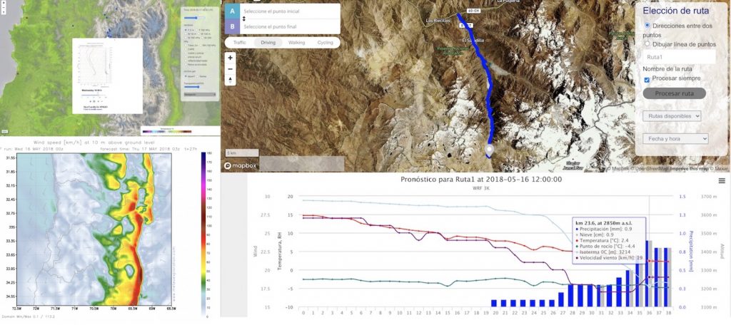
One of the tools offered is an interactive map with sites of interest for which vertical profiles (Skew-T diagrams) or time series of various meteorological variables can be obtained. These in turn can be viewed on dedicated pages with greater detail and resolution. Multivariate maps are provided at hourly resolution of the WRF model output and at three-hour intervals over a longer period of time from the GFS model. There is a section with satellite images and the possibility for the user to request a vertical cut of the atmosphere between any two points on the map or to create a route and obtain the weather conditions at any point along it.

It is possible to add information from local meteorological stations, so as to be able to compare the data with that of the model. In this way one can see if there is any constant error that should be accounted for in the final forecast.

Please contact us for more details and an estimation of costs.